Cattle driving big forest loss in Peru’s ‘under-appreciated’ Amazon
Recent analysis finds cattle ranching is quietly and quickly deforesting huge swaths of rainforest in the heart of Peru.
- Despite having some of Peru's highest levels of deforestation, its Central Amazon is often overlooked by conservationists and NGOs.
- Cattle grazing in the area has ramped up over the past decade, leading to a deforestation hotspot almost the size of Connecticut that lost a quarter of its tree cover over 15 years.
- Deforestation is infiltrating protected areas and the ranges of threatened, endemic species.
- Recent data indicate 2016 tree cover loss rates may be more than triple those of 2015.
When one thinks of cattle ranchers destroying the Amazon rainforest, one usually thinks of Brazil. And for good reason: cattle ranching continues to be the leading cause of deforestation in the Brazilian Amazon. Currently, about two-thirds of cleared forest in the region becomes pasture for scores of cattle herds that today collectively number around 60 million head – or two cows for every seven Brazilians. But a new report by the Monitoring of the Andean Amazon Project (MAAP) has caught another vast swathe of forest loss linked to cattle ranching in a neighboring country not known for its cowboy culture: Peru.
Looking at the Department of Huánuco in central Peru, researchers with MAAP discovered a large area of forest loss equaling 24,520 hectares over the last three years – Amazonian destruction over an area four times bigger than Manhattan.
“It is likely that cattle ranching has been the driver in that part of the country for awhile, just no one really documented it,” said Matt Finer, a researcher with the Amazon Conservation Association.
Peru’s neglected Central Amazon
In recent analyses, MAAP has discovered that Peru’s Central Amazon has the highest levels of forest destruction in the country even though this region—including the Department of Huánuco—has received far less media and NGO attention than areas like the Madre de Dios in the southeast or Loreto in the north.
Peru’s Central Amazon “just seems like an under-appreciated area,” according to Finer.
Moreover, the bulk of this deforestation is likely illegal, according to MAAP, which found that most forest loss occurred outside areas zoned by the government for agricultural use.
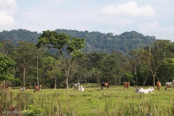
Finer said they are certain the area is being used for cattle because they can see via satellite that the land has been transformed into pasture and “in some hi-res images we can actually see cows.”
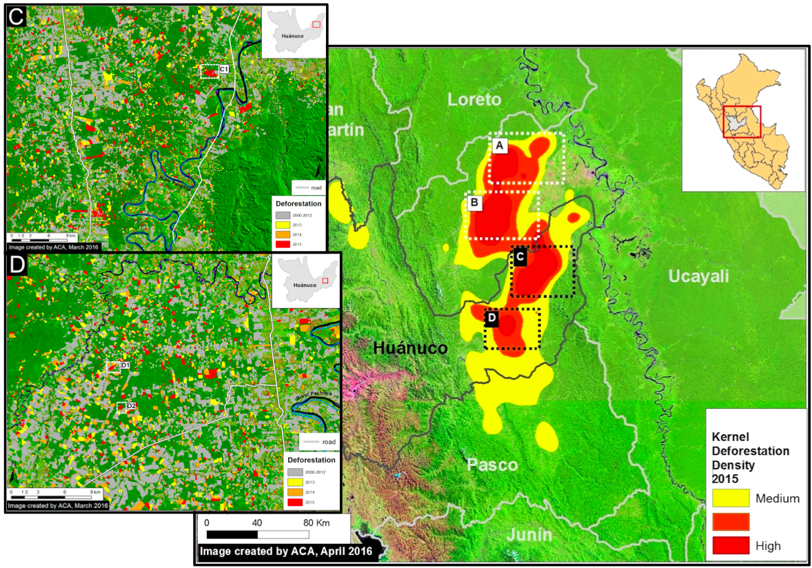
The cattle-driven deforestation hotspot extends from the region of Pasco up through Huanuco and well into Ucayali. Data from Data from PNCB/MINAM, UMD/GLAD, MTC; images courtesy of MAAP.

The region contains intact forest landscapes (IFLs), which are particularly large, continuous, and undisturbed tracts of primary forest. Those within the approximated deforestation hotspot show degradation since 2001. The hotspot is also close to – and in one case overlaps with – Alliance for Zero Extinction (AZE) sites that demarcate the ranges of threatened, endemic species. Data from Hansen/UMD/Google/USGS/NASA, accessed through Global Forest Watch. Satellite imagery from Google Earth.
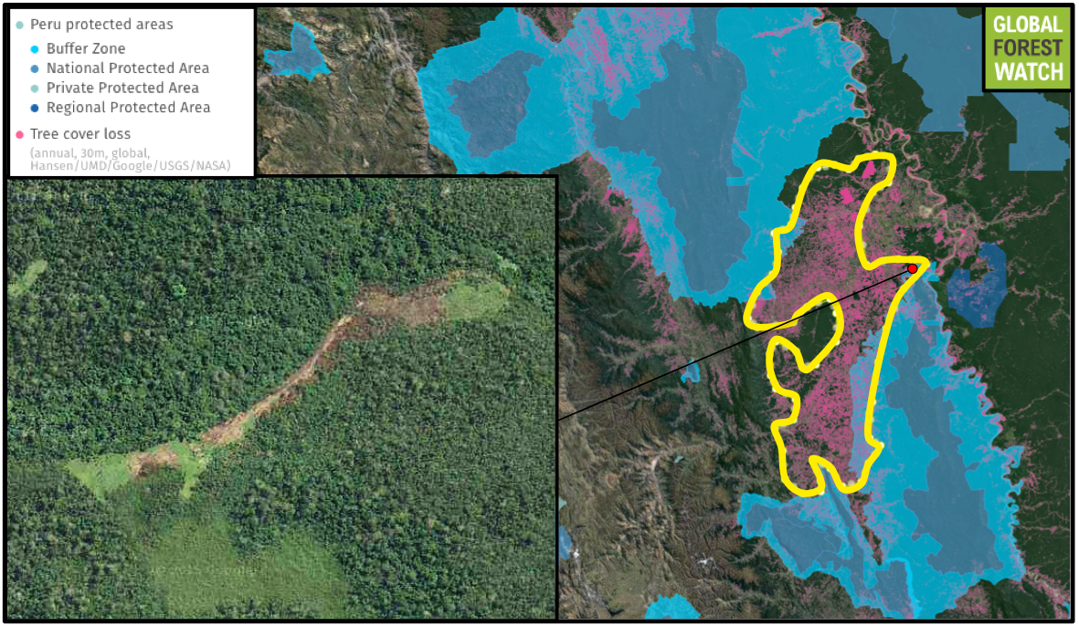
The deforestation hotspot is also edging into protected areas, including El Sira Communal Reserve (ESCR) and the buffer zone of Codillera Azul National Park. The inset shows an area where around 20 hectares of forest loss occurred from 2008 – 2013 inside ESCR. This particular area is also within the only known range of several highly threatened frog species. Data from Hansen/UMD/Google/USGS/NASA, accessed through Global Forest Watch. Satellite imagery from Google Earth.
Enrique Oritz, Vice President of the Amazon Conservation Association, described the Huánuco region as “a beautiful place” with high biodiversity and many endemic species, meaning they are found no-where else.
Huánuco has “a unique geography that dissects the Andes, with an extensive cloud and montane forest cover that makes it as a center of endemism for many plant and animal taxa groups.”
But the deforestation is even impacting protected areas. For example, the cattle deforestation outlined by MAAP has infiltrated parts of the buffer zone of Sira Communal Reserve, which was created in 2001.
Sira Communal Reserve protects the Cordillera El Sira, a mountain range that rises 2,500 meters from the forest floor and is co-managed by the Ashaninka, Asheninka, Yanesha and Shipibo-Conibo indigenous groups that live there.
The protected area is home to a plethora of wildlife, several species of which are endemic and threatened with extinction. The Sira poison dart frog (Ranitomeya sirensis), Maria’s giant glass frog (Nymphargus mariae), the purple-sided leaf frog (Phyllomedusa baltea) and the Laguna toad (Rhinella nesiotes) are endemic to the area. While the Sira poison dart frog is listed as Least Concern by the IUCN, the other three are considered Endangered.
The mountain range also houses two endemic birds: the Sira tanager (Tangara phillipsi), which is considered Near Threatened, and the Sira curassow (Pauxi koepckeae). The latter species may be of the highest concern in the area as it is both listed Critically Endangered and is in decline due to hunting and habitat destruction. The Sira currasow was only recognized as a distinct species five years ago.
According to ParksWatch, Sira Communal Reserve should be considered a vulnerable park.
“The main threat to the protected area stems from logging, which occurs in several ways throughout the communal reserve,” the NGO writes in a report from 2003. “At the same time, the construction of highways and access roads, excessive extraction of forest resources, disorganized agriculture and cattle ranching and gold mining in part of the communal reserve, plus the possible presence of drug traffickers in the area make protecting natural resources and the entire protected area a complex matter.”
The same report, although a decade old now, found that cattle ranching was already growing in the area, especially along Highway 5N. They note that cattle ranching in the area was also very unproductive—requiring 1 to 2 hectares per head of cattle for “mediocre yields”—and largely dependent on ever-expanding deforestation.
“Every year ranchers cut down more forest to plant grass to maintain their herds. Cattle management is not intensively done with rotating corrals and production of forage, which to a degree would reduce the impact on the forest,” the report reads. “Livestock herding in the area is based on grazing, forcing ranchers to constantly convert forestland into pastures.”
The report also noted that in 2003 cattle ranching was being pushed by regional governments and other groups like the Consortium for Sustainable Development in Ucayali and the Pichis Palcazu Project, which also lobbied for palm oil.
From fish and chicken to beef
Wendy Francesconi, an environmental scientist with the Lima-based International Center for Tropical Agriculture, along with her colleagues from other institutions, recently examined cattle-driven deforestation in Huánuco’s neighboring district of Ucalyi.
Francesconi said that Peru has long been a “chicken or fish rather than a beef consuming country.” Indeed, Peruvians have one of the lowest consumption of beef on the continent, and, according to the FAO, also eat less meat in general than most of their neighbors.
Yet, she expects that to change as Peru’s economy continues to grow.
“It is well known the global trend is for greater household income to lead to greater consumption of meat and dairy products,” she said.
However, beef doesn’t hold the same place culturally in Peru as it would in say Brazil or Argentina. Production here remains relatively small. This, according to Francesconi, is likely due to the lack of suitable topography for beef. Peru has little flat prairie or vast wetlands that could be easily converted to cattle production such as Brazil’s Pantanal or Argentina’s pampas. Instead the country is made of coastal deserts, Andean mountains and the Amazon.
Historically, cattle ranching in Peru had been regulated to the mountainous highlands and, said Francesconi, was “characterized by small-scaled operations mainly for subsistence purposes.”
She also noted that under such conditions cattle ranching proved important to small holders both for income and food security, as well as animal labor.
Yet in recent years, this once highland activity has been moving into parts of the lowland Amazon region. Francesconi believes this is a result of farmers clearing forest for crops and then turning to cattle after the jungle soil rapidly degrades.
“This cycle allows the farmer to keep possession of the land and make use of it,” she said, adding that “the expansion of cattle ranching practices in the Amazon is a consequence of the introduction of crop farming for subsistence or cash crops.”
Oritz agreed, saying that farmers are simply employing cattle as a way to “justify the take over of lands.”
These are not large ranches, according to Ortiz, marking another difference with cattle production in Brazil. Instead, he said, Peru’s cattle are still “in small plots of less than 1 to 5 hectares,” – but when you add all these small plots together they begin to create vast landscapes of forest destruction.
Zooming out
Data compiled by the University of Maryland and visualized on the forest-monitoring platform Global Forest Watch further shows that cattle-driven deforestation isn’t just a problem in Huánuco. The forest loss hotspot extends north through Ucayali and south into Junín, comprising an area of around 1.35 million hectares. This region—an area a little smaller than Connecticut—lost a quarter of its tree cover from 2001-2014.
Protected areas in this wider region, like Sira Communal Reserve, have been hard hit as well, losing about 22 percent of their tree cover during the same period.
And deforestation appears to be rising. Last year from January to June, 10,352 deforestation alerts were recorded in the region by the Global Land Analysis and Discovery (GLAD) system developed by the University of Maryland. The satellite system tracks deforestation in near-real time (i.e., weekly), and can spot deforestation in areas as small as 30-by-30 meters. However, 34,836 GLAD Alerts were recorded for the region during the same period in 2016, indicating that forest loss activity in the region has more than tripled over the past year.
Francesconi pointed out that during the Climate Summit in Peru in 2014, the nation pledged to restore three million hectares of degraded forests. To that end Peru has set up the National Forest Conservation Program and is working on designing carbon mitigation strategies for four commodities: cacao, coffee, palm oil, and, yes, cattle ranching.
“While still in formulation, the strategies will probably include the improvement of management practices, productivity, value chains and climate smart agriculture,” she said.
To date, Central Peru has comparatively escaped the scrutiny of activists and NGOs. But data on ongoing deforestation suggests that may need to change – and quickly – if Peru is to meet its climate and forest conservation goals.
Citations:
- Alliance for Zero Extinction (2010). 2010 AZE Update. www.zeroextinction.org. Accessed through Global Forest Watch on [date]. www.globalforestwatch.org
- Bax, V., Francesconi, W., & Quintero, M. (2016). Spatial modeling of deforestation processes in the Central Peruvian Amazon. Journal for Nature Conservation, 29, 79-88.
- Finer M, Novoa S, Cruz C, Peña N (2016) Deforestation Hotspot in the central Peruvian Amazon. MAAP: 37.
- Greenpeace, University of Maryland, World Resources Institute and Transparent World. “Intact Forest Landscapes. 2000/2013” Accessed through Global Forest Watch on July 19, 2016. www.globalforestwatch.org
- Hansen, M. C., P. V. Potapov, R. Moore, M. Hancher, S. A. Turubanova, A. Tyukavina, D. Thau, S. V. Stehman, S. J. Goetz, T. R. Loveland, A. Kommareddy, A. Egorov, L. Chini, C. O. Justice, and J. R. G. Townshend. 2013. “High-Resolution Global Maps of 21st-Century Forest Cover Change.” Science 342 (15 November): 850–53. Data available on-line from:http://earthenginepartners.appspot.com/science-2013-global-forest. Accessed through Global Forest Watch on [date]. www.globalforestwatch.org
- Hansen, M.C., A. Krylov, A. Tyukavina, P.V. Potapov, S. Turubanova, B. Zutta, S. Ifo, B. Margono, F. Stolle, and R. Moore. 2016. Humid tropical forest disturbance alerts using Landsat data. Environmental Research Letters, 11 (3). Accessed through Global Forest Watch on [date]. www.globalforestwatch.orgServicio Nacional de Áreas Naturales Protegidas
- (SERNANP). “Peru protected areas.” Accessed through Global Forest Watch on [date]. www.globalforestwatch.com.
Facebook comments