Challenges and opportunities of developing Environmental Decision Support Systems
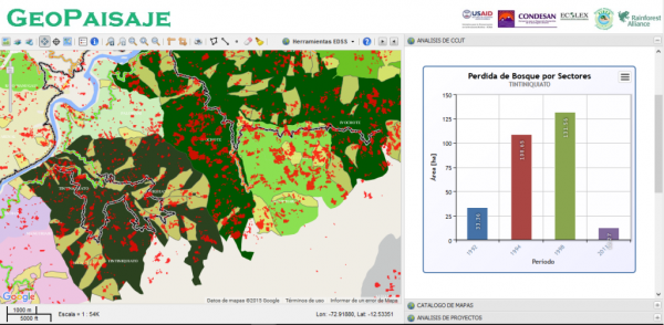
ffective management of natural resources requires tools that help key stakeholders to foresee the impacts of their investments and actions. Environmental decision support systems can help policy makers and practitioners target key areas embedded in rapid land use change dynamics, monitor stakeholders’ interventions at different scales, and support land use planning by aligning conservation and development objectives. With that aim, we at CONDESAN have been working on developing an Environmental Decision Support System (EDSS) that can provide key data and analysis to local governments. The EDSS developed is called GeoPaisaje, and is based upon a landscape approach that recognizes different uses and stakeholders spread throughout the landscape. It is an online, computer-based information tool that integrates different types and sources of information: from historical land use and cover changes (LUCC) and forest fragmentation, to productive and infrastructure investments in specific territorial units (e.g. farm, community, parish). It enables key users—such as local stakeholders, government officials or project managers—to do integrated spatial analysis in a given landscape, and should be especially helpful for decision makers with no specific training in GIS or data management. The EDSS is available at http://geopaisaje.geoi-bol.com/. A first version of it was applied to two landscapes in Ecuador and Peru through a partnership with the Rainforest Alliance and the Initiative for Conservation in the Andean Amazon (ICAA).
EDSS are promising tools to assist decision-making processes by targeting specific policy objectives. For instance, GeoPaisaje is useful for: 1) identifying key areas with fast land use and cover change processes to target future interventions, 2) estimating the level of pressure affecting forest lands within management units (such as farms or communities), and 3) monitoring projects being promoted by local governments or NGOs, and analyzing where such investments are being allocated and distributed within a landscape. EDSS are flexible enough to integrate new sources of information and analysis to respond to any other relevant questions. In fact, for more than two decades EDSS have been evolving and integrating new computational and GIS functions that have allowed them to be flexible tools for decision makers.
Nonetheless, in the context of the Andean countries—where decision making is very often characterized both limited information and a lack of robust analysis—EDSS are still considered novel tools whose application face several challenges that need to be overcome to foster the use of any EDSS:
- A high level of commitment from local governments to systematize and generate quality information that can periodically feed the tool.
- Specialized technical skills to manage complex databases (including geographical), which also involves maintenance costs that need to be considered.
- Optimal use of EDSS requires training for the government officials that will be managing the tool.
- The development of new features and analysis modules will require new resources.
In that context, it is very important that efforts to support effective management of natural resources not only provide new tools to support decision-making processes, but also promote capacity building in local governments that allow them to assume more roles and responsibilities in their development.
Bustamante, Macarena
.
Facebook comments